Wednesday, June 20, 2012

MACHU PICCHU!!!!!!

Ok so this is Machu Picchu. It is by far the place I was most excited to visit on this whole trip and it did not disappoint. It was a bit stressful getting there since our train to Aguas Calientes, the city at the base of Machu Picchu, was about three hours late picking us up. That gave us just enough time for about 2 hours of sleep in our hostel before waking up and getting ready get in line to catch the first bus up the mountain. We got in line at 5:00 and made it onto the second bus. The first one is at 5:30 and they're supposed to leave every 10 minutes, but our bus actually left right after the first one. I could try to explain what it's like to reach the top of the mountain and see this place, but I really just can't do it. It's indescribable. Someone we met here in La Paz explained it best I think. She said that because of all the hype surrounding Machu Picchu and all that you hear about it, you would think that when you get there it would be impossible for it to meet your expectations, but then it exceeds them. I feel like that's about the best way to attempt to describe Machu Picchu. The city and the surrounding mountains are more impressive than whatever you can picture in your head.

This right here is a trail that the Inca once used to get to Machu Picchu. It's not the famous Inca trail that you could follow 85 kilometers back to Cusco from here. This trail goes around the other side of Mount Machu Picchu, and today they call this the Inca bridge. I found a sign pointing to it and a guide said it was only 10 minutes out and 10 minutes to get back. We had plenty of time until the sun was to rise over the mountains so we checked it out. The views along this trail are ridiculous. Especially in the early morning when we were there, because then all the clouds are really low and the taller mountains off in the distance are orange on top because the sunlight is able to reach their peaks even though it hasn't risen yet where you're standing. Sadly, my camera was incapable of capturing all that color off in the distance, so here's a look back at the path before you reach the bridge.

It's called the Inca bridge because of that terrifying gap you can see there in the path. Today it's spanned by a few wooden planks, but there's no test of bravery here. The path is fenced off before you get to the bridge, so it's more a test of stupidity if you want to go for it. I've found that in South America, a place that's usually not too crazy about guard rails and extra safety precautions, if they went out of their way to stop you from going somewhere, you better not go there. What I'm wondering though is how the Inca got across, because that gap there looks intentionally built and symmetrical, and with so many Inca ruins still around and standing strong, I find it difficult to believe that their bridge collapsed and they needed the Peruvians to come in and fix it with some wooden planks.

This is the view looking out from up around the top of that first picture of the Inca bridge trail. It's a bummer you can't see the mountains in it.

I think this was taken from the same place just looking to the left now instead of out across the valley.

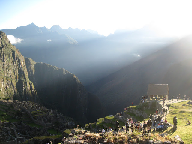
We made it back for the sunrise. It came up right over the top of this mountain and sent beams of light shooting to either side. Definitely the coolest sunrise I've seen. Sorry Isla del Sol.

This is how the light shone to the left of the mountain peak and onto the city.

After the sunrise we went back out by the buses to meet with our tour guide for the day. Here's a map of everything. You can enlarge it. It's got English and everything.

This is the gate to the city. The door is so tall because the emperor was always carried through it. They closed it at night to keep animals out like bears, foxes, and pumas, which are still sighted in the city occasionally.

This is the sun temple. It has two windows, one for the summer equinox and one for the winter equinox. (At least I believe it's equinox not solstice. I really don't know the difference. Kinda crazy considering how important they both were to every ancient civilization ever.) During each (equinox?) the sun rises so that its light shines perfectly through the window so that it can illuminate the entire stone altar you see there in the middle. We were there June 17, and this happens on June 21st. Almost saw it.

More terraces. Preventing landslides and providing farmland. Smart people.

I wanted to go into the common area, but you're not allowed to.

After our tour was over we thought we'd go climb a mountain. This is Huayna Picchu, or Wayna Picchu. Same thing. They let 400 people up here every day out of the 2,000 daily visitors to Machu Picchu. We were told that we were crazy if we didn't book a spot up there. It was definitely worth it.

There were sooooo many steps.

View of Machu Picchu from close to the top of Wayna Picchu.

I have tried to finish this post 3 times. I´ve had the internet die and erase my words twice now. Just enjoy the pictures. I´m not captioning them a third time because I actually wrote quite a bit from this point on and   there´s other stuff I´d rather do right now.


Monday, June 18, 2012

Cusco and the Sacred Valley of the Incas

I feel like before this trip I would have simply titled this post, "The Day Before Machu Picchu" because that's what it was for me going into it, but there really were lots of interesting things on this trip and some really cool places we went. We started things off with a  12 or so hour bus ride to Cusco starting at 9 a.m. in La Paz. Normally that would really suck, but we were on this double decker bus with these huge seats that reclined so far it was like a bed. Also, I was in the front so I had this cool thing I could put my feet up on and a huge window to look out, which was cool until the sun started setting but we had drapes for that. We arrived at Cusco around 8ish I think. They're behind an hour though in Peru. We got a taxi to our hostel which was a pretty nice place to stay at. We found dinner and checked out the city which is really quite beautiful. There's lots of really old stone churches and museums and the whole place is just very alive. We couldn't stay out too long though because we had to wake up for our bus the next morning.

So here's Cusco as taken from the bus. You can't see it in this picture but on the sides of one of the mountains they have "Viva el Peru" and some kind of coat of arms of the city drawn onto the mountain so that you can see it from really far away. It's pretty cool.

Our first stop was at a farm to see some llamas, alpacas, and guanacos (they're what you get when you smoosh a llama and an alpaca together). Of course the real reason for the stop was to get us to go in the store they had there but we just loved these guys. Especially the shaggy ball of awesomeness that's front and center in this picture.

We named him Alpaca Marley for his dreadlocks. He's the dude.

But he wouldn't let me feed him.

A little further down the road we stopped to see a great view of the Sacred Valley or el Valle Sagrado. That's the Sacred River running through it. It was a big deal to the Inca and we saw a lot more of it the next day at and around Machu Picchu.

This is the Inca settlement of Pisaq. The terraces always had to be built first before they built anything on the mountaintops. They prevented landslides during the rainy season by storing and releasing the water at a controlled rate. They did this by filling the bottom layer of each terrace with large stones followed by a layer of gravel, a layer of sand, and finally a layer of soil on top so that the terrace could be used for farming as well. Our guide told us that the buildings on top were for the nobles in the area and also served as an astronomical observatory.

This is also the site of the largest known Inca cemetery. The Inca used to place their dead in the sides of mountains so that their spirits could be reborn again out of the Earth.

Here's a better view of everything on the top. I wound up climbing all over those rocks in front of the cloud on the left half of the picture.

This is the modern town of Pisaq. We stopped here to check out all the shops and silver stores.

This is part of the main market street. They had tons of stuff here. Peru has lots of really nice stuff you can buy, but it's a more expensive country than Bolivia. It's about 2.6 soles per dollar as opposed to 6.9 bolivianos per dollar.

These are the Inca ruins in Ollantaytambo. There's some pretty cool stuff around and on top of this place.

For example, this mountain which is across from the last picture has two Inca faces carved into it. One of them, which I don't believe you can see in this picture because it's on the far left side, is positioned so that the sun rises right behind the tip of the face's nose on the summer solstice. So when they saw from the observatory on top of the ruins that the sun was rising behind the nose, they knew it was time to plant their crops. The other face is in between the two structures you can see built not quite halfway up the mountain. It's a profile.

I just thought the way they fit these huge stones together which such precision is nuts. It really is difficult to find any kind of a gap in between these, and they had to drag them up a ramp on the other side of the hill.


The Inca were also crazy water resource engineers. I actually took a whole bunch of pictures on this trip of the channels and drainage systems they used. This one transports water from a glacier all they way down to a temple dedicated to water. Oh and it travels underground too and then finally through grooves cut into stone.

Tuesday, June 12, 2012

photosynth

Ok I finally found wifi and uploaded my pictures to http://photosynth.net/

The problem is that when I uploaded from my iPod I selected "do not share." There's some copywrite stuff and other things I wanted to check out first before sharing the pictures. Sadly, in order to make the pictures public from the website, you have to select each individual picture, load it, then select "share." This is such a painfully slow process that there's just no way I'm doing it. If I get wifi here again, I'll try and remember to get on my iPod and try making the pictures public from there. Otherwise I'll be up until about 1:00 a.m. doing this from my laptop, as it takes a loooonnnngg time to load one of these panoramic pictures using the internet I have here. I did make one of them viewable though if you want to check it out. It's the first one I took, the famous "view behind the house in Mallasilla" picture. I think to find it you just click the link I already provided and search for pictures by KyleDLowry. That should work. If not.......I don't know. Sorry.

Thursday, June 7, 2012

Copacabana / Isla del Sol: Day 2

I highly recommend reading day 1 first.

Ok you're done reading about day 1 at Isla del Sol. Day 2 consisted of lots of hiking and paying the occasional toll to the locals along the path to Yumani in the south end of the island. It was a good day.

We woke up to see the sunrise. Luckily this didn't require a hike, just a short walk to the other side of Challapampa.

This is the hostel we stayed at. It was pretty awesome, and somehow very warm in there at night, which was a real change from what we've gotten used to.

I think I took this same picture the day before but who cares. The water wasn't shimmering then.

Here's a view of Challapampa from way up on what we determined was the highest or at least very close to the highest point on the island. We seriously could not leave this place. Any direction you looked you would see just about the most amazing view of your life.

Way off in the back of this picture and to the left is about where we watched the sunset from the day before.

This is the path all the way back to the north end of the island. This is still pretty early in the hike south though. This was at a checkpoint where we had to buy tickets to continue.

Skip ahead 3 hours or so and we're in Copacabana again. While Caroline and Conrad ate dinner by the beach, I decided to climb Cerro Calvario instead. Copacabana is actually a site of pilgrimage due to the Basilica of Our Lady of Copacabana, the big white structure in the middle of the city on the left side of the picture. Because of all the pilgrims visiting the city, they built a site dedicated to the stations of the cross way up on the highest point overlooking the city. I was hungry, but I really wanted to go up there so I skipped dinner. It was worth it.
View of the bay from way up high.

Here's the basilica. I had to zoom in really far so it's a little blurry.

On top of Cerro Calvario.

How could a student at a Marianist university explain not seeing the famous statue of Mary if they found themselves in Copacabana? When I left for Cerro Calvario I had about an hour before I had to meet Caroline and Conrad to catch our bus. I hustled. This is in the courtyard outside of the basilica.

The entrance.


They were pretty big on no picture taking in there. There were people doing more than just touring the place who were praying so I decided to be as little of a disrespectful jerk as possible and just look. I'll try and google image some pictures for you. I didn't have much time either, so I asked a couple tourists where the statue of Mary was and weaved through hallways and up stairs until I found it. Then I had to peace out of there because I still needed to find some snacks to eat on the bus for dinner.

Here's a link to a picture with some info of the statue http://saints.sqpn.com/our-lady-of-copacabana/


Speaking of the bus, it broke down just outside Copacabana and we had to wait for another one to pick us up. Also, I got to play with my new panorama picture taking app on my iPod quite a bit on this trip. Pretty much all the best pictures were taken using that, but I still have yet to find a place with wifi where I can upload them to the internet. One day I'll post a link on here to a whole bunch of them.


Copacabana / Isla del Sol: Day 1

Ok so Sunday and Monday we went to Copacabana and Isla del Sol. It was a pretty quick trip. We took a bus from La Paz to Copacabana, then a 2 hour boat ride to the north end of Isla del Sol, or Island of the Sun in English, otherwise known as the most beautiful place I have ever seen. I seriously love this Island and could have easily spent a week there doing nothing but hiking and seeing all the amazing views. On the bus we met a guy from Belgium named Nikki that we actually already met a few nights ago at the Wild Rover Hostel and a German guy named Christian. We all decided to travel together and had a great time. Here's some highlights of the trip in order.

The bus has to stop in this small town on Lake Titicaca where the only way to keep going is to take a boat the short distance to the other side. We all got tickets to be taken across on one boat and our bus to another. We then got back on the bus and finished the drive to Copacabana.

This is one of the many spectacular views from the bus as you near Copacabana.

I have pictures of Copacabana from Sunday. For now we're skipping ahead to Challapampa, just about my favorite little pueblo ever. This is where we stayed on the north end of Isla del Sol. It's much smaller and less touristy than the southern village of Yumani that we walked to on Sunday, which we all liked about this place. We stayed here Monday night in a hostel right on the beach for the equivalent of about $3. I could probably stay in this place for a long time if given the opportunity.

This is the number one example I have of a picture doing the real thing absolutely no justice at all. On Monday we walked about 45 minutes to see the Inca Ruins on the north end of the island and the sunset. This picture was taken pretty early in that walk and it was the first of many places on this island where our jaws just dropped and we had to stop to take it all in.

There were animals everywhere on this walk. Pigs, cows, donkeys, sheep, and some dogs. This picture is taken back at where we were standing when the previous picture was taken.

Did I mention how beautiful this island is?

These are some Inca ruins know as "Laberinto" or "Chincana". It's this cool maze-like structure with all these little passageways leading all over the place and intersecting each other. I really wanted to take this picture because before I left the U.S. I looked up pictures from Isla del Sol on my iPod and I wound up setting one just like this as my background. My goal when I got here was to find the exact same place and take the same picture. I just though that would be cool. Going inside and running around through these ruins is cooler.

More of Laberinto.

You could see a couple really big mountains from Isla del Sol. These are the ones you can see from pretty much anywhere on the north side of the island. They looked sooooo cool when the sun was setting, but my camera couldn't quite capture it because they were so far away.

The sun setting from the western tip of the island that we walked to. The Inca believed that this island was the birthplace of the sun. It's easy to see why when you watch the sun set and rise here.

Taken on the way back after the sun went down. Laberinto is in the very bottom left corner for reference.


When we got back to Challapampa we found a place to get dinner (more delicious fish with quinoa soup), then we played some interesting card games at the hostel for the rest of the night.

Ok now check out day 2 for the sunrise, the highest point on the island that we couldn't force ourselves to leave, and Copacabana.