Saturday, July 7, 2012

Some Work Results and Horse Riding, but first......

Soft kitty, warm kitty, little ball of fur........I miss Big Bang Theory, among many other things.
Yeah this is Lupe. I don't think I've posted a picture of her yet. She sleeps on my UDXC bookbag pretty much all day every day.


This is really disgusting water. I never ever want to know what is actually in here, but it probably doesn't take much imagination to guess pretty accurately what is.


You pour it in one of these......


.....using a janky funnel you made by cutting up a water bottle and putting a little hole in one of the little bumps on the bottom.....


......then much less disgusting looking water comes out of the bottom and is collected here....


....so that it looks like this.....


....and this....


....but it's still a far cry from clean tap water (on the left). 
Disclaimer: these filters are small scale and don't treat the water nearly as much as is needed. They just take care of most of the turbidity. If you smell this water, you'll know pretty easily that you shouldn't drink it. It still needs some activated carbon treatment, which I'm working on, and some disinfection.


Horseback riding!!

This is the city from wayyyyy up on a mountain.

I don't know why this picture had to rotate itself, but that's the Devil's Molar peak, which I believe I posted a picture of a long time ago as seen from way down in Mallasilla.

We think this is Mallasa, the place beyond Mallasilla.

The path we took on the mountain

This is Missi. She's crazy and competitive and like to go fast. She made things a bit scary at times, but she also made the experience a lot of fun.

And here's some more pictures of the path we took through the mountains. 


These pictures are all actually 2 weeks old. We rode horses on June 23rd and the work pictures are earlier than that. Since then I've made 4 more filters to compare retention time and treatment when using different amounts of filter sand. Right now I'm trying to use this oven we have in the workshop to activate some carbon to further treat the water with. We've been doing things around La Paz and I've been trying to get my report on the sand filters written. This is almost certainly going to be my last blog post unless I decide to write one more when I get home that summarizes the whole trip. My flight home leaves super early Wednesday morning. I hope you enjoyed reading and seeing all the pictures. I guess I'll see you soon. 

Wednesday, June 20, 2012

MACHU PICCHU!!!!!!

Ok so this is Machu Picchu. It is by far the place I was most excited to visit on this whole trip and it did not disappoint. It was a bit stressful getting there since our train to Aguas Calientes, the city at the base of Machu Picchu, was about three hours late picking us up. That gave us just enough time for about 2 hours of sleep in our hostel before waking up and getting ready get in line to catch the first bus up the mountain. We got in line at 5:00 and made it onto the second bus. The first one is at 5:30 and they're supposed to leave every 10 minutes, but our bus actually left right after the first one. I could try to explain what it's like to reach the top of the mountain and see this place, but I really just can't do it. It's indescribable. Someone we met here in La Paz explained it best I think. She said that because of all the hype surrounding Machu Picchu and all that you hear about it, you would think that when you get there it would be impossible for it to meet your expectations, but then it exceeds them. I feel like that's about the best way to attempt to describe Machu Picchu. The city and the surrounding mountains are more impressive than whatever you can picture in your head.

This right here is a trail that the Inca once used to get to Machu Picchu. It's not the famous Inca trail that you could follow 85 kilometers back to Cusco from here. This trail goes around the other side of Mount Machu Picchu, and today they call this the Inca bridge. I found a sign pointing to it and a guide said it was only 10 minutes out and 10 minutes to get back. We had plenty of time until the sun was to rise over the mountains so we checked it out. The views along this trail are ridiculous. Especially in the early morning when we were there, because then all the clouds are really low and the taller mountains off in the distance are orange on top because the sunlight is able to reach their peaks even though it hasn't risen yet where you're standing. Sadly, my camera was incapable of capturing all that color off in the distance, so here's a look back at the path before you reach the bridge.

It's called the Inca bridge because of that terrifying gap you can see there in the path. Today it's spanned by a few wooden planks, but there's no test of bravery here. The path is fenced off before you get to the bridge, so it's more a test of stupidity if you want to go for it. I've found that in South America, a place that's usually not too crazy about guard rails and extra safety precautions, if they went out of their way to stop you from going somewhere, you better not go there. What I'm wondering though is how the Inca got across, because that gap there looks intentionally built and symmetrical, and with so many Inca ruins still around and standing strong, I find it difficult to believe that their bridge collapsed and they needed the Peruvians to come in and fix it with some wooden planks.

This is the view looking out from up around the top of that first picture of the Inca bridge trail. It's a bummer you can't see the mountains in it.

I think this was taken from the same place just looking to the left now instead of out across the valley.

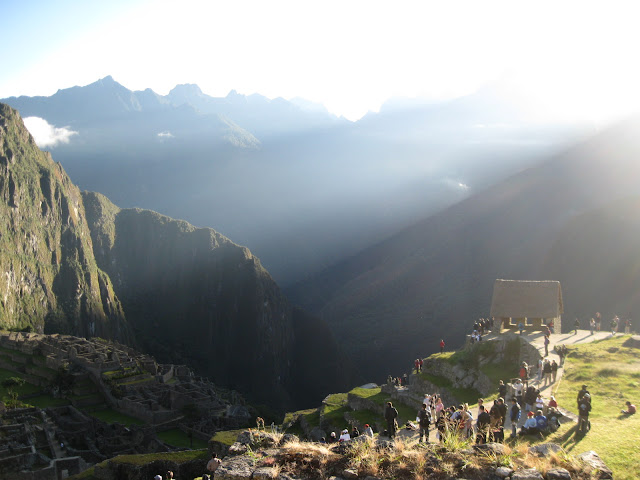
We made it back for the sunrise. It came up right over the top of this mountain and sent beams of light shooting to either side. Definitely the coolest sunrise I've seen. Sorry Isla del Sol.

This is how the light shone to the left of the mountain peak and onto the city.

After the sunrise we went back out by the buses to meet with our tour guide for the day. Here's a map of everything. You can enlarge it. It's got English and everything.

This is the gate to the city. The door is so tall because the emperor was always carried through it. They closed it at night to keep animals out like bears, foxes, and pumas, which are still sighted in the city occasionally.

This is the sun temple. It has two windows, one for the summer equinox and one for the winter equinox. (At least I believe it's equinox not solstice. I really don't know the difference. Kinda crazy considering how important they both were to every ancient civilization ever.) During each (equinox?) the sun rises so that its light shines perfectly through the window so that it can illuminate the entire stone altar you see there in the middle. We were there June 17, and this happens on June 21st. Almost saw it.

More terraces. Preventing landslides and providing farmland. Smart people.

I wanted to go into the common area, but you're not allowed to.

After our tour was over we thought we'd go climb a mountain. This is Huayna Picchu, or Wayna Picchu. Same thing. They let 400 people up here every day out of the 2,000 daily visitors to Machu Picchu. We were told that we were crazy if we didn't book a spot up there. It was definitely worth it.

There were sooooo many steps.

View of Machu Picchu from close to the top of Wayna Picchu.

I have tried to finish this post 3 times. I´ve had the internet die and erase my words twice now. Just enjoy the pictures. I´m not captioning them a third time because I actually wrote quite a bit from this point on and   there´s other stuff I´d rather do right now.


Monday, June 18, 2012

Cusco and the Sacred Valley of the Incas

I feel like before this trip I would have simply titled this post, "The Day Before Machu Picchu" because that's what it was for me going into it, but there really were lots of interesting things on this trip and some really cool places we went. We started things off with a  12 or so hour bus ride to Cusco starting at 9 a.m. in La Paz. Normally that would really suck, but we were on this double decker bus with these huge seats that reclined so far it was like a bed. Also, I was in the front so I had this cool thing I could put my feet up on and a huge window to look out, which was cool until the sun started setting but we had drapes for that. We arrived at Cusco around 8ish I think. They're behind an hour though in Peru. We got a taxi to our hostel which was a pretty nice place to stay at. We found dinner and checked out the city which is really quite beautiful. There's lots of really old stone churches and museums and the whole place is just very alive. We couldn't stay out too long though because we had to wake up for our bus the next morning.

So here's Cusco as taken from the bus. You can't see it in this picture but on the sides of one of the mountains they have "Viva el Peru" and some kind of coat of arms of the city drawn onto the mountain so that you can see it from really far away. It's pretty cool.

Our first stop was at a farm to see some llamas, alpacas, and guanacos (they're what you get when you smoosh a llama and an alpaca together). Of course the real reason for the stop was to get us to go in the store they had there but we just loved these guys. Especially the shaggy ball of awesomeness that's front and center in this picture.

We named him Alpaca Marley for his dreadlocks. He's the dude.

But he wouldn't let me feed him.

A little further down the road we stopped to see a great view of the Sacred Valley or el Valle Sagrado. That's the Sacred River running through it. It was a big deal to the Inca and we saw a lot more of it the next day at and around Machu Picchu.

This is the Inca settlement of Pisaq. The terraces always had to be built first before they built anything on the mountaintops. They prevented landslides during the rainy season by storing and releasing the water at a controlled rate. They did this by filling the bottom layer of each terrace with large stones followed by a layer of gravel, a layer of sand, and finally a layer of soil on top so that the terrace could be used for farming as well. Our guide told us that the buildings on top were for the nobles in the area and also served as an astronomical observatory.

This is also the site of the largest known Inca cemetery. The Inca used to place their dead in the sides of mountains so that their spirits could be reborn again out of the Earth.

Here's a better view of everything on the top. I wound up climbing all over those rocks in front of the cloud on the left half of the picture.

This is the modern town of Pisaq. We stopped here to check out all the shops and silver stores.

This is part of the main market street. They had tons of stuff here. Peru has lots of really nice stuff you can buy, but it's a more expensive country than Bolivia. It's about 2.6 soles per dollar as opposed to 6.9 bolivianos per dollar.

These are the Inca ruins in Ollantaytambo. There's some pretty cool stuff around and on top of this place.

For example, this mountain which is across from the last picture has two Inca faces carved into it. One of them, which I don't believe you can see in this picture because it's on the far left side, is positioned so that the sun rises right behind the tip of the face's nose on the summer solstice. So when they saw from the observatory on top of the ruins that the sun was rising behind the nose, they knew it was time to plant their crops. The other face is in between the two structures you can see built not quite halfway up the mountain. It's a profile.

I just thought the way they fit these huge stones together which such precision is nuts. It really is difficult to find any kind of a gap in between these, and they had to drag them up a ramp on the other side of the hill.


The Inca were also crazy water resource engineers. I actually took a whole bunch of pictures on this trip of the channels and drainage systems they used. This one transports water from a glacier all they way down to a temple dedicated to water. Oh and it travels underground too and then finally through grooves cut into stone.